Walking The Ridgeway - Britain's Oldest Road
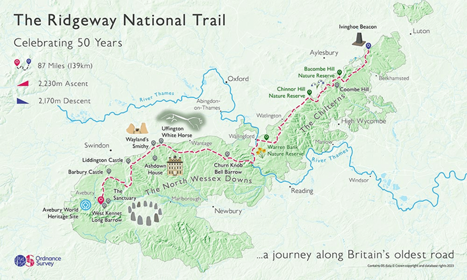
From the World Heritage Site of Avebury, Wiltshire in the west, to Ivinghoe Beacon, Buckinghamshire in the east, extending some 87 miles (140km) following a ‘ridge’ of chalk hills, The Ridgeway follows the same route over high ground used since prehistoric times by travelers, herdsmen and soldiers. The Ridgeway is one of the most accessible National Trails and provides a tranquil retreat within a living landscape, used and enjoyed by walkers, runners, cyclists and riders alike.
At the halfway point, The Ridgeway meets The Thames Path, another National Trail at Goring-on-Thames, with The Ridgeway trail to the west passing through The North Wessex Downs Area of Outstanding Natural Beauty (AONB) covering and giving views over open chalkland downs, with ancient monuments including Stone Age and Bronze Age Barrows, Iron Age Hill Forts and White Horses. This section of the trail is more rural, with few villages on the path, walkers should carry enough refreshments or plan to take a small detour to visit the many beautiful villages or call in at the various pubs nearby.
Heading east from The Thames, you are walking alongside the Thames River, through the rich woodlands, valleys and rolling hills that form part of The Chilterns (AONB) and on through nature reserves and chalk grassland habitats. The trail passes through several villages, the grounds of the Prime Ministers country residence at Chequers and into market towns where refreshments and other facilities are easily accessible.
The Ridgeway follows a combination of footpaths, bridleways and byways which in some sections are Byways Open to All Traffic (BOATS) allowing motorised access with Traffic Regulation Orders, restricting access during winter months to protect the ancient landscape. This combination means that when walking in some sections you may share the path with runners, cyclists, riders and motorised vehicles.
The Ridgeway can be enjoyed by walkers all year round with the landscape and views changing with the seasons. Preparing properly for your walk, depending on the time of year, will enhance your enjoyment even more and taking some simple steps ahead of time will ensure you remain safe and well. This straightforward safety guide for walkers is definitely worthy of a few moments of your time including advice on how to avoid ticks, blisters, thunderstorms and summer heat – we hope not all in one day! When venturing out into rural areas and open countryside we’d recommend becoming familiar with the Countryside Code. There is great guidance for dog owners and the care that needs to be taken around livestock as well as how to understand different signposts and markings.
Accessing The Ridgeway is easy. There are car parks near, or on all sections of The Ridgeway, some free, some requiring payment, but all are busier at weekends and during summer months so plan ahead. When parking, do so considerately and avoid parking in front of gates not on verges or the trail itself as this may cause damage to the landscape. There are railway stations and bus routes near to The Ridgeway, these can be found by using this interactive map.
Whether you’re planning to walk The Ridgeway in one go or divide your walk into separate sections over several days, weeks or months, the trail is very well-marked and clearly signposted throughout its length.
For those who enjoy a ‘pub walk’ we have put together many here, all of which are on and around The Ridgeway, and provide descriptions and .gpx files. To use the files, they should be downloaded and then imported to a programme/app and then opened from within the programme/app. They have been checked using OS Maps, Komoot and All Trails. It’s recommended that you check opening days and times of your destination pub ahead of your walk to avoid disappointment!
When planning any walk, give consideration to the following:
Mobile phone coverage and internet access are not always available dependent on where you are on The Ridgeway.
Appropriate footwear for uneven surfaces, often muddy and wet.
Layers of clothing including warm and waterproof.
Refreshments, as water and food supplies may be several miles away.
Conditions change so it’s worth checking for any path closures or diversions on National Trails and always check the weather before setting out using the Met Office and typing the location where you’ll be walking.
Notify someone where you’re going and when you expect to be back.
Navigation for digital maps, interactive maps, route descriptions and possible itineraries visit The National Trails website. For paper maps, Ordnance Survey Landrangers 165, 173, 174, 175 or alternatively Harveys produce a waterproof Ridgeway route map.
Accommodation on The Ridgeway is limited, with most being found ‘off the path’ in the pubs, guest houses, hotels and camping sites of the nearby villages and towns. It’s recommended that accommodation be booked in advance and we’d suggest using Google and searching for ‘accommodation along the ridgeway’.
If you encounter a problem on The Ridgeway, such as a damaged gate or blocked trail, you should report it to The Ridgeway Officer on 01865 810224, or email [email protected] or use the National Trails contact page here
In the event of an emergency please dial 999 and state the nature of the emergency and which service is needed. You may need to give precise location information.: Emergency services use the What3Words app which divides the world into 3m x 3m squares, each with a unique three-word address. This can be given to the operator even if you are in a remote area with no address. Alternatively, you can read your phone's latitude and longitude GPS coordinates from a mapping app. Modern smartphones have built-in features (Advanced Mobile Location or Emergency Location Service) that automatically send your GPS coordinates to operators when you call, even if you cannot speak.
Further information, resources and links on The Ridgeway can be found on National Trails